Products
Products
GPS Assist


Overview

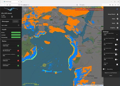
GPS Assist is software that uses data from an existing maritime radar to estimate the lat/long position of a ship or unmanned surface vessel (USV) by comparing received radar data with expected radar returns that are predicted from the appearance of local terrain and shorelines. The calculated position is then compared with GPS-received position, with errors being used to infer missing, spoofed or jammed GPS signals. When such a condition is detected, GPS-Assist can raise an alarm and create its own stream of NMEA-based navigation data with the goal of providing emergency navigational information.

GPS Assist works with existing maritime radars. The ship's normal processing and display of the radar data is unaffected by GPS Assist, which simply piggybacks on to the data stream to process the radar video. The radar video is scan converted to an image which is then compared to a predicted radar image derived from a terrain database. The prediction process uses terrain and coastline information to create a predicted radar image. This predicted image is compared with the actual radar image and an alignment process adjusts the real data to match with the predicted data. The error between observed and predicted positions is used to adjust the estimated position of the ship. GPS Assist takes standard NMEA-0183 navigation data as an input and continually compares the reported GPS position with the estimated position. If a significant error is detected, the incoming GPS stream is suspected to be missing, spoofed or jammed. At this point, GPS Assist can simply generate an alarm to permit another sub-system to handle the consequences, or else GPS Assist can generate its own stream of NMEA-0183 data with corrected navigation data.

Feature
■  Interfaces to standard maritime radars, including:
    •  Simrad
    •  Raymarine
    •  Furuno
    •  Hensoldt
    •  JRC
    •  Raytheon
■  Input navigation data as NMEA-0183
■  Input radar video as ASTERIX CAT-240, SPx or Simrad (other formats are possible with external conversion)
■  Automatically detects missing, lost or jammed GPS
■  Alarm signal on missing or incorrect GPS
■  Automatically generate NMEA data stream with estimated position
■  Browser-based interface for set-up and configuration
■  Turn-on-and-go operation
■  Windows 10 or later, or Linux compatible
■  Worldwide coverage after preload of terrain data
■  Heartbeat message (a network message for status and errors)
■  A separate radar interface card or format conversion module may be needed for some radar models

Powered by Aeroer Aeroer Technology Co., Ltd. All Rights Reserved. 2010 Contact: Info@aeroer.com ICP: 11011415
回顶部