Overview
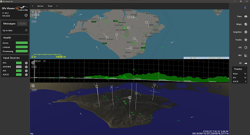
SPx Viewer-3D is a software application for Windows or Linux that proves a 3D visualisation of radar track reports arriving in SPx or ASTERIX format, as well as AIS and ADS-B messages. The software provides 2D PPI and RHI views and also a 3D view of track reports. The user may manipulate the viewpoint to observe the tracks and history trails from any angle.
SPx Viewer-3D receives track reports over a network interface and displays the track symbol as an overlay to a map or rendered terrain. Track history is shown as a sequence of trail dots, a track vector shows the estimated direction and speed of travel of the track and optional display of additional track details, such as track name and height. A typical application of the viewer is to show radar tracks from 2D or 3D radars, along with AIS and ADS-B information.
Input Tracks
Track input formats and sources include SPx, ASTERIX, AIS and ADS-B. SPx Viewer-3D supports multiple sources of the same track type.
Each track source has a unique IP address and port and any permutation and combination of supported radar track sources can be displayed; for example SPx track reports from a primary radar video, SPx track reports from a secondary IFF radar video, and ADS-B messages.
Proprietary and legacy track input formats, such as NMEA, YLC and GeoJSON, may be supported via Cambridge Pixel's SPx Track Manager product.
Visualization
On Windows, SPx Viewer-3D is a standard Windows application and on Linux, the application is a server with a browser-based user interface.
The application provides an intuitive display of the tracks and local terrain, allowing the user to change the viewpoint in real-time.
Features
■ Platform:
• Windows 10 (or later version) and Linux
■ Configuration:
• Configuration file read at start-up
• Application or browser-based user interface
■ Track Inputs:
• SPx, ASTERIX, AIS or ADS-B
• ASTERIX CAT-1 (with CAT-2) CAT-10, CAT-48 (with CAT-34), CAT-20, CAT-62
• AIS input: NMEA-0183
• ADS-B input: CAT-21, KAL, AVR, BEAST, AIRNAV, FR24
■ Display:
• PPI display - shows 2D view with maps and charts.
• RHI display - Range Height Indicator view, shows 2D cross-section of terrain and track positioning.
• 3D display - shows 3D-projected terrain with tracks mapped in 3D.
■ Browsers Supported:
• Chrome, Safari, Edge, Firefox