Overview
The Maritime Display Framework provides a solid baseline for development of a custom maritime radar display application. The framework includes the ability to display scan-converted primary radar video, radar video track information, electronic charts, secondary transponder information and also camera video.
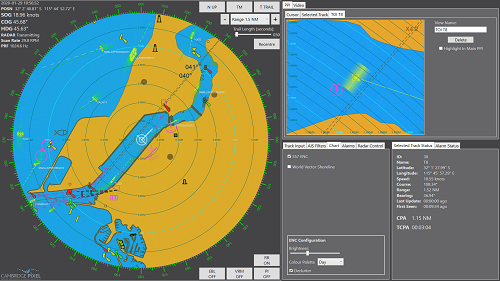
The Maritime Display Framework provides various tools for processing of information common to maritime displays, such as the ability to generate predictive vectors, calculations of a tracked object’s closest point of approach (CPA) and time to CPA (TCPA), thereby warning if there is a danger of collision with other ships. Such features are typical within automatic radar plotting aid (ARPA) solutions.
The Maritime Display Framework is written in the C# language and is designed for development of a Windows .NET WPF-based client application. The Maritime Display Framework’s default configuration can be used to provide a functional maritime display solution without any development. Alternatively, the framework can be adapted, extended and enhanced for a custom solution.
The modular software design separates the controls that perform display functions and controls that interact with the radar transceiver, allowing a common display to be used for a variety of radar antennas and transceivers. The aesthetics of the display solution can be customised, for example to look the same as an existing Integrated Bridge System.
Comprehensive alarm capabilities, including target track alarm type and target dependence (such as hazardous cargo status provided in AIS) are available.
Feature
■ Windows 10 touch screen compatible
■ Written in C# .NET
■ Supports display resolutions up to 8K UHD (7680x4320)
■ S-57 / S-63 electronic chart support
■ Up to 350 radar and/or AIS targets
■ Track input from SPx Server
■ Supports auto and manual track initiation
■ AIS display filters including: Range, Ahead only, Moving only, Large ships
■ Main PPI with multiple rectangular Regions Of Interest (ROIs)
■ Multiple CCTV inputs
■ EBL, VRM and parallel index lines
■ Provision for radar control and status
■ Heading/North/Course Up modes
■ True and relative trails support
■ Range scale adjustment
■ Ground stabilisation for navigation purposes
■ CPA and TCPA alarms
■ Display colour palette options (day/dusk/night)
■ Trail history retention
